It became obvious that we would need to hire a car to be able to do anything extensive in the way of sightseeing and finally, at the last of 10 car rentals, found one. It cost $60 per day with 100 free kilometers, and a $.25 charge per extra kilometer. I thought we would be able to do the trip within the 200 kilometers (silly me!). We rented a Japanese made 4 wheel drive station wagon (that should have warned me).
However as we were renting the car, I looked in the local Marlborough County phone book, and listed were several people with the Slape surname, one of whom lived in Picton. After a coffee on the main street, I went to see these Slapes, and then we went to Blenheim, the county seat of Marlborough County. (The story of the Slapes is told on other pages in this trip log).
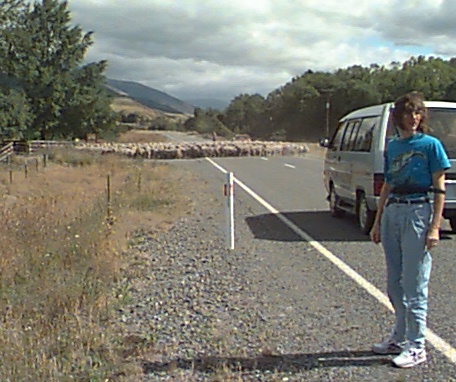
The most astonishing thing for us was the complete lack of any gas stations, roadside stores, etc. The valley was inhabited, but we encountered little traffic in 130 km of driving. It created a great sense of remoteness. The farms changed quickly from vinyards, to fruit farms, to some grain and then to mostly grazing. At one point Christine had to get out of the car to clear the road: photo
I was overcome by allergies at this point in the trip (I have been having quite a bit of difficulty with the pollens in New Zealand) and so we decided to find a place to stay for the night. St. Arnaud has a population of probably 300 or so. It is center for tramping and skiing, but the very few motel rooms available were taken by a wedding party and I was not keen on the accomodation available for itinerant trampers.
Tophouse was established in the 1850-60's time period in the earliest days of New Zealand colonization. Tophouse is an historic farm, which has been a hotel and bar for most of its life. It is of cobb construction (a mixture of mud, straw, manure and cement) which had fallen into disrepair until Mike and Melody restored it over the past few years. Besides its early start, it is also known for some dramatic murders that occured there in the 1880's. I know our bedroom door opened, seemingly by itself, at least once during our stay, so I guess the ghosts are still there.
We had a delighful stay at Tophouse. It was interesting to talk to Mike about the farming in that area. They are located at an altitude of about 1,000 meters. The night before they had a mild frost and Mike said that they have had frosts in every month of the year. It is therefore impossible to grow most crops, although, on his 700 acres he did have a field of turnips (which are greatly appreciated by the rather large rabbit population). Mostly he raises cattle and he has about 100 head. Like cattlemen everywhere he is at the mercy of the market prices. Five years ago cattle averaged about $560 a head and now they are down to about $100. However prices have been rising, now in the fall of the year when they would normally drop, and he is optimistic.
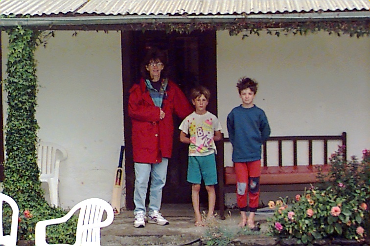
We had dinner with Mike (whose original ancestors in New Zealand arrived by boat from Scotland in the 1840's) and Melody and their two sons Karl and Jared. The boys go to a school which has 29 pupils, the greatest number in recent years. Karl is fighting with problems with the "A" drive of his computer which only goes to prove that there are no havens from computer glitches. The next morning, at breakfast, Christine learned how to cook toast over an open hearth fire -- in response to her question of "where's the toaster". Before we left I took the following photo of Christine with the two boys. photo. I told them I would put this photo on the website and they said they would look for it at school where they have access to the internet.
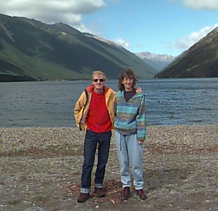
We also saw fantails, the NZ robin and Australian black swans as well as several other birds. The only disturbing thing on this brief visit was the appearance, as we were leaving of a couple of groups of people with powerful motorboats who were setting up to go waterskiing. It seems such a sadness to disrupt the tranquility of this lake (one of the few in New Zealand) with such activity. We asked one of the boaters to take a photograph of us without the dock and boats in the background. He, of course, included them, but with the aid of the photographic software I have cropped them out of the following photo. It reminded Christine and me somewhat of Lake Louise in Alberta before the tourist infiltrations of the 60's and 70's.
When we went through the Anglican Cathedral, Christine pointed out the plaque in honour of the valiant Englanders who withstood the fury of the Luftwaffe attacks in WWII. She felt my heroism had finally been 'recognized'.
We then made our way along the coast back to Picton, to take the ferry to return to Wellington. This was a "scenic" drive. That is a New Zealand word which describes a road that has hard turns every 50 meters, clings perilously to the side of steep hills, which is one lane wide, which is used for two directional traffic and which has a speed limit of 100 kph (at which speed which most New Zealanders try to drive). The driver sees nothing other than the road. The passenger, if imbued with the correct sense of confidence in the driver, has a spectacular view. However, the passenger who feels a great need to see impending doom has as terrifying a trip as the driver.
At one point on this section of the trip we passed a quaint arrow sign which said "Outward Bound School". It was obviously misplaced -- it should have been located at the airport arrival gate, in Auchland.
We returned the car in Picton. We had driven 360 km, so the total cost was $160 plus $30 for gas for the car -- a bit pricey, but we certainly covered a lot of territory in the two days. We then caught the slow ferry back to Wellingnton. It was crowded with true trampers -- people heavily laden with backpacks, sleeping bags, etc. Many were speaking a number of European tongues, and were obviously just coming down from a 'high'.
The trip on the ferry was almost four hours -- I think a next trip will be strictly by Lynx.
. . .And the walk home only took 15 minutes.